Town-Owned Conservation Areas Under Conservation Commission Management
The Conservation Commission manages approximately 150 acres of conservation land on behalf of the Town of Shutesbury. The properties below were acquired through the state LAND Grant Program (formerly known as the Self-Help Grant), acquisition through tax titles, and Town Meeting votes, gifts, and purchases. Properties acquired through the LAND Grant Program are subject to state regulations and must be managed by the Conservation Commission for conservation and passive recreation purposes.
Land held by the Conservation Commission is considered permanently protected because it would take a two-thirds vote of the Massachusetts State Legislature to convert the parcel to another non-conservation use. Many of these open spaces currently help protect wetlands and tributaries, provide public access to other large blocks of protected lands, and together help to extend the habitat and recreation value of the state lands. Permanently protected Town-owned open space totals 0.9 percent of Shutesbury’s total land area (Source: 2022 Open Space and Recreation Plan).
A Conservation Management Plan exists for the South Brook Conservation Area (2001 South Brook Conservation Area Management Plan). The Commission is in the process of developing a town-wide conservation management plan for all properties under its management. Public access facilities, trails, and maintenance are coordinated with the Open Space and Recreation Committees.
West Quabbin Woodlands Conservation Area: In 2022, Annual Town Meeting approved a Community Preservation Act (CPA) project to acquire a 34-acre parcel to be called the West Quabbin Woodlands Conservation Area. This acquisition is still in progress. For updates on this project, see West Quabbin Woodlands Conservation Area Acquisition.
Lake Wyola and South Brook Conservation Areas: a combined 97-acre parcel at the south end of Lake Wyola. In 2021 and 2022, the Conservation Commission and Open Space Committee oversaw a small CPA-funded project to evaluate and map the trails in this conservation area. This project is ongoing, but the hope is that it will result in needed trail repairs, a trail map, and signage. In late 2022, Evan Jones and four other volunteers donated materials and labor to replace a dangerously deteriorating footbridge.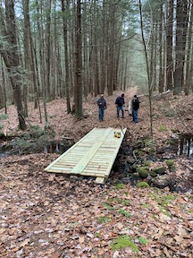
Haskins Meadow Conservation Area: a 31.1-acre parcel between East Leverett Road and January Hills Road.
Top of the Lake Conservation Area: a .6 acre pocket park with stone kayak/canoe launch located off Merrill Drive. In 2021 and 2022, a CPA grant supported improvements on this small parcel, including adding a small boat launch, parking area, fencing, and landscaping. Volunteers planted native shrubs and perennials. Future plans include the addition of a picnic table to this lovely lakeside public space.
Montague Road Conservation Area: a 3.1-acre parcel near Dudley Pond.
Mount Mineral Road Parcel: a 1.7-acre, land-locked parcel.
Cove Road Parcel: a 1.4-acre lakefront parcel with picnic and kayak launch.
Lake Wyola: the 14.8 acres of land under water and the Lake Wyola Dam. The dam and water rights to Lake Wyola were acquired in 1966 through a Conservation Commission Self-Help Grant. See the links below for more information:
- LAND Grant (formerly Self-Help Grant) Regulations-301 CMR 5.00
- Lake Wyola Dam and Water Rights Acquisition Records-1966